The difference between building in Calgary's inner-city communities like Beltline versus developing in the deep ravines of Fish Creek Park is essentially a story of two very different ground profiles. In the downtown core, you are dealing with dense glacial till overlaying Paskapoo sandstone—a stiff, competent foundation that rarely moves. But push south toward the Bow River valley or into the northwest escarpments along Nose Hill, and you encounter interbedded clay shale, colluvium, and ancient landslide deposits that can creep or fail under load. For any cut, fill, or retaining structure in these zones, a proper slope stabilization design is non-negotiable—it determines whether your project holds or slides. Before we commit to a reinforcement scheme we often run a [MASW survey](/masw-vs30/) to map shear-wave velocity contrasts across the profile, or install vertical drains in low-permeability clay layers to accelerate pore-pressure dissipation behind the slope face.
Glacial till over weathered shale reduces effective friction angles by up to 40% in Calgary's ravines – design must account for residual shear strength, not peak.
Methodology and scope
Calgary's slope failures rarely follow textbook models because the local geology is layered and anisotropic—glacial till can sit directly on weathered shale that has a residual friction angle of only 18 degrees. That is why our design methodology always starts with the Canadian Foundation Engineering Manual (CFEM 4th ed.) and the NBCC 2020 seismic provisions, but we also lean heavily on FHWA-NHI-05-092 for reinforced slopes and the USGS landslide-susceptibility framework adapted for Alberta's Foothills. We treat each project as a unique system:
Limit-equilibrium analysis (Bishop simplified, Spencer, Morgenstern-Price) with pore-water pressure modeling from seasonal monitoring wells
Finite-element deformation checks using Plaxis 2D/3D to capture strain-softening in clay shale
Probabilistic sensitivity runs to quantify how water-table fluctuation affects factor of safety
Because the city's freeze-thaw cycles can open tension cracks that accelerate infiltration, we also incorporate permeability testing at multiple depths to calibrate drainage requirements and instrumentation for real-time slope movement tracking.
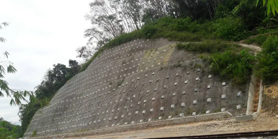
Technical reference image — Calgary
Local considerations
In Calgary we frequently see developers assume that a 3:1 cut in glacial till will hold forever, only to have a wet spring activate a shallow translational slide along the till-shale contact. That interface acts as a hydraulic barrier—water perches above the shale, reducing effective stress and triggering movement at factors of safety as high as 1.3. The second common failure mode is progressive toe erosion from Bow River tributaries, which removes passive resistance and unloads the slope base. A slope stabilization design that ignores these two mechanisms will almost certainly require remediation within five years, costing multiples of the original assessment. That is why we always couple the stability analysis with a geotechnical drainage study to address both perched water and toe scour, and we verify soil layering through test pits before finalizing any reinforcement layout.
We run multi-method slope stability models (Bishop, Spencer, Morgenstern-Price) and 2D/3D deformation analyses in Plaxis to capture strain-softening in clay shale, tension crack development, and pore-pressure effects. Output includes factor-of-safety contours and displacement envelopes.
02
Reinforcement & Drainage System Design
Based on the stability results we design soil nails, geogrid-reinforced fills, tieback anchors, and subsurface drainage blankets. Every system is sized for Calgary's freeze-thaw cycles and groundwater fluctuations, with construction drawings and QA/QC specifications.
03
Instrumentation & Monitoring Plan
We install inclinometers, piezometers, and surface prisms to track slope movement and pore pressure during and after construction. Data is reviewed weekly, and thresholds trigger pre-defined contingency actions—keeping your project safe and on schedule.
Applicable standards
NBCC 2020 – Division B, Part 4 (foundations & slopes), FHWA-NHI-05-092 – Mechanically Stabilized Earth Walls & Reinforced Slopes, ASTM D3080-04 – Direct shear test (residual strength), CFEM 4th ed. – Canadian Foundation Engineering Manual
Frequently asked questions
What is the typical cost range for a slope stabilization design in Calgary?
For a standard residential or small commercial slope (up to 10 m high, 50 m long), the design fee ranges from CA$1.980 to CA$9.140 depending on complexity, number of sections analyzed, and whether you need instrumentation. Larger cut slopes or sites with buried utilities can push the upper end higher.
How long does a slope stabilization design take from site visit to final report?
A typical timeline is 3 to 5 weeks. The first week covers field investigation and sampling, the second week is lab testing and soil parameter determination, and the final 1–2 weeks are spent on stability modeling, reinforcement design, and report writing. If instrumentation monitoring is required, add 4 to 8 weeks.
What is the difference between a factor of safety of 1.3 and 1.5 in practical terms?
A factor of safety of 1.3 means the slope is marginally stable—small changes in water table, freeze-thaw cycles, or seismic shaking can trigger failure. A factor of 1.5 provides a comfortable margin for long-term performance, accounting for uncertainty in soil strength and groundwater conditions. For Calgary's glacial till over clay shale, we always target 1.5 static and 1.1 seismic.
Do I need a slope stabilization design for a single-family home near a ravine?
Yes, if your lot is within 15 m of a ravine crest or if the City of Calgary's Landslide Susceptibility Map shows moderate to high risk. The development permit will require a geotechnical report that includes slope stability analysis. Even if not mandated, it protects your investment from future movement and insurance complications.