Building in Calgary means dealing with two very different ground stories. Up along the Bow River valley, you hit coarse gravels and glacial till with decent stiffness; head south toward Fish Creek or the old lakebed areas around Midnapore, and you're suddenly in deep lacustrine clays and silts that respond to seismic shaking very differently. That contrast is exactly why MASW profiling matters here. A single shear wave velocity survey across a site can reveal the stiffness layering that no borehole alone will catch. When we combine surface wave analysis with a CPT sounding for continuous stratigraphy, the seismic site class assignment becomes far more reliable. The NBCC 2020 seismic hazard is not uniform across the city footprint.
MASW gives you the stiffness profile that boreholes miss — critical for NBCC seismic site class in Calgary's variable glacial deposits.
Methodology and scope
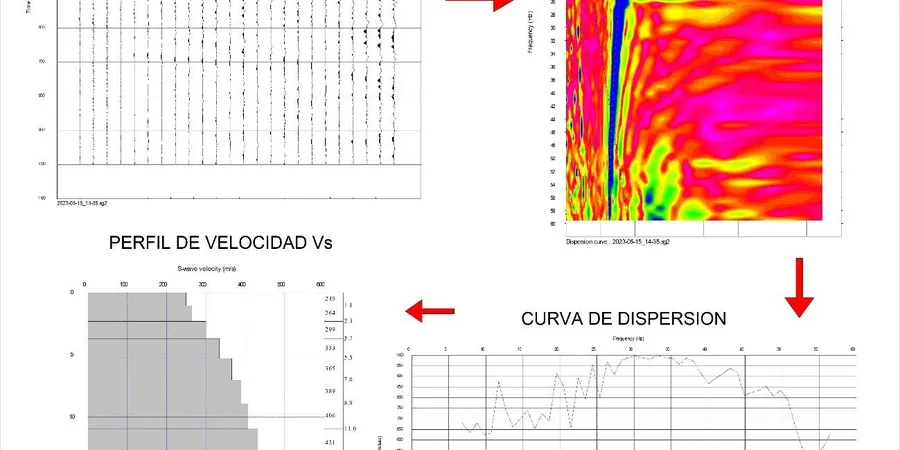
Calgary sits on a thick sequence of Pleistocene tills and glaciolacustrine deposits that can exceed 50 meters in places. The shear wave velocity in the upper 30 meters (VS30) varies significantly depending on whether your site is underlain by dense till (VS30 often above 400 m/s) or soft lacustrine clay (VS30 dropping below 250 m/s). Our MASW surveys deploy a 24-channel geophone array with a 1-meter receiver spacing and a sledgehammer source, recording Rayleigh wave dispersion curves inverted to generate 1D and 2D velocity profiles. We follow the ASTM D4428 standard for the field work. For projects where deeper bedrock data is needed, we pair MASW with a tomografía sísmica to image velocity contrasts at greater depths. The final deliverable includes VS30, time-averaged velocity to 30 m, and the NEHRP site class (A through F) required by the Alberta Building Code.
Technical reference image — Calgary
Local considerations
The NBCC 2020 seismic hazard maps give Calgary a peak ground acceleration (PGA) of 0.08g to 0.12g for the 2% in 50 years event — moderate but not negligible. The real risk is site amplification. A building on soft lacustrine clay in the south can experience ground motion 1.5 to 2 times stronger than the same structure on dense till in the northwest. That's why the Alberta Building Code requires a Site Class determination per NBCC Table 4.1.8.4.A. Skipping a proper VS30 survey and relying on generic soil maps can lead to undersized seismic design or unnecessary over-design. We've seen projects where the default assumption of Site Class C turned out to be Site Class D after the MASW survey, changing the base shear calculation significantly.
Standard 24-channel array with 1 m spacing, providing a 1D shear wave velocity profile to 30 m depth. Suitable for small to medium residential or commercial sites where a single representative profile is sufficient.
02
Multi-Array 2D MASW Tomography
Multiple overlapping arrays along a survey line, producing a 2D velocity cross-section. Ideal for large sites with lateral variability or for identifying buried channels and soft zones before foundation design.
03
VS30 for Seismic Site Classification
Focused service extracting VS30 (time-averaged shear wave velocity in the upper 30 m) and assigning the NEHRP/NBCC Site Class. Delivered with a one-page summary suitable for regulatory submission.
04
MASW + Refraction Tomography Combined
Integrated P-wave refraction and S-wave MASW surveys to characterize both stiffness and stratigraphy. Useful for deep excavations, tunnel alignment studies, or when bedrock depth is a design parameter.
Applicable standards
ASTM D4428 / D4428M — Standard Test Methods for Crosshole Seismic Testing, NBCC 2020 Table 4.1.8.4.A — Seismic Site Classification, ASCE 7-16 Section 20.3 — Site Class Determination
Frequently asked questions
How does MASW compare to a standard SPT borehole for determining VS30 in Calgary?
MASW measures shear wave velocity directly across a volume of soil, while SPT boreholes give point measurements of N-values that are then correlated to VS30 through empirical relationships. In Calgary's glaciolacustrine clays, those correlations can be off by 15 to 25 percent. MASW provides a continuous velocity profile without drilling, so it captures stiffness changes between boreholes. We typically recommend MASW as a complement to SPT for reliable site class assignment.
What is the typical cost for a MASW survey in Calgary?
A standard single-array MASW survey with VS30 report in Calgary ranges from CA$1.960 to CA$3.700, depending on site access, array length, and whether a 2D profile is required. Multi-array 2D tomography for larger sites can exceed CA$5.000. We provide a fixed-price quote after a quick site visit to confirm surface conditions.
Do I need a MASW survey if I already have geotechnical boreholes on site?
Boreholes give you soil classification and strength, but they don't measure shear wave velocity directly. The NBCC requires VS30 for site class determination. If your borehole logs show soft clay layers or variable till density, an MASW survey can confirm whether the VS30 falls into Site Class C or D. We often see cases where borehole-based estimates place the site at the boundary between two classes, and the MASW data resolves the classification.